|
Disaster based early warning and awareness services like GDACS, GloFAS, EFAS, GDO, EDO, EFFIS, and GWIS rely heavily upon exposure and vulnerable features, susceptible to natural impact, as critical input to various internal models at different stages. The definition of exposure and vulnerable features varies between use-cases. For example experts typically still need to downsample raw feature data as input for those models based on the model’s area of coverage and other characteristics. In order to meet such demands, together with the EU Joint Research Center (JRC, Ispra), we developed a first version of a new service, acting as a middleware between disaster experts and raw Volunteered Geographic Information, such as OpenStreetMap. It allows to custom modify multiple dataset with a high level of feature control and filter options. This makes them ready to use off the shelf for above mentioned services and similar models. We announce the first release of this service API, where we have successfully processed key themes critical for most of the disaster scenarios. It uses also the OSM history analytics platform ohsome.org of the Heidelberg Institute for Geoinformation Technology (HeiGIT) and adds further domain specific functionalities: Exposure Data Hub Application Programming Interface (EDH RESTful API Service) Key characteristics of this service are listed below. They shall give users high data control and custom processing capabilities. A detailed User and Developer guide is coming soon, and therefore kindly stay tuned for future news. 1. Theme Definition
> Experts will define their own definitions of exposure and vulnerable feature per use-case and will simply refer to them for subsequent queries based on standards like UN’s Sendai Framework et cetera, thus avoiding any semantic clashes with others. In other words, various definitions of for example “High-graded Hospital” are possible to process and also to fetch the data against potentially several available data sources. 2. Area of Interest
> Various options to define spatial extend are incorporated to avoid subsequent data crops by non-GIS experts with ever changing administrative boundaries, especially for automated workflows. Examples include Bounding Box, GeoJSON, tile ID and Name String. 3. Data Aggregate
> Subsequent down sampling is avoided by providing pixel resolution and projection. Other checks like attribute filters et cetera are already defined inside with respect to the given “Theme Definition”. 4. Data Format
> Multiple data formats are supported (GeoJSON, GeoTIF, KML, and ShapeFile) to meet the input demand of known range of services. Further export formats would be added based on the users’ feedback. 5. Custom Exposure Function
> The API, furthermore, allows experts to define their own scientifically backed vulnerability functions to combine different VGI datasets to useful quantifiable attributes to be able to use off the shelf for risk mapping. Considering the complexity and sensitivity of it, GIS and disaster experts intervention is a must during the process. This includes also initial possibilities to define use case based quality indicators (using current attributes of the features). This shall be extended by future ohsome API functions in the next phase. Sample Example as Demo The following example is a 250 meter aggregation of Hospital theme (based on Sendai Framework) for Heidelberg, DE region, where feature count based on its centre is considered. 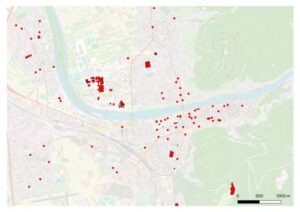
Fig.1: OpenStreetMap basemap with raw hospital features. (Data: (c) OSM contributors) 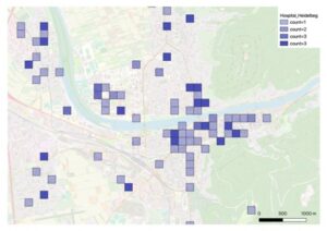
Fig.2: OpenStreetMap basemap with 250m aggregated (GeoJSON) hospital features based on feature count. Data: (c) OSM contributors) State of the Service Currently, the global dataset for the following 9 Sendai themes are available to download internally for experts for preliminary investigation, bug tracking, and feedback. Soon, it will be made public with a User Guide for anyone to download. Inevitably, the API itself is designed to publish data considering copyright and access rights. Although the service is capable to scale up to other data sources, OpenStreetMap is being used for phase one. Sendai themes currently covered: 1. Health 2. Education 3. Road 4. Railway 5. Bridge 6. Airport 7. Power Generation Plant 8. Cultural Heritage Site 9. Water Treatment Plant Interested developers can check our Github repositories to provide feedback at this stage. Kindly note that because of administrative project requirements active development is currently taking place in an internal Gitlab platform (private access). The public Github repositories shall get updated with master branch regularly. Server repository > https://github.com/GIScience/global_exposure_edh_server Database repository > https://github.com/GIScience/global_exposure_edh_db OpenStreetMap History Data Analysis Framework repository > https://github.com/GIScience/oshdb Some ohsome References: Raifer, M., Troilo, R., Kowatsch, F., Auer, M., Loos, L., Marx, S., Przybill, K., Fendrich, S., Mocnik, F.-B.& Zipf, A. (2019): OSHDB: a framework for spatio-temporal analysis of OpenStreetMap history data.Open Geospatial Data, Software and Standards 2019 4:3. https://doi.org/10.1186/s40965-019-0061-3 Auer, M.; Eckle, M.; Fendrich, S.; Griesbaum, L.; Kowatsch, F.; Marx, S.; Raifer, M.; Schott, M.; Troilo, R.; Zipf, A. (2018): Towards Using the Potential of OpenStreetMap History for Disaster Activation Monitoring. ISCRAM 2018. Rochester. NY. US. Ludwig, C. ; Zipf, A. (2019): Exploring regional differences in the representation of urban green spaces in OpenStreetMap. Proceedings of the GeoCultGIS - Geographic and Cultural Aspects of Geo-Information: Issues and Solutions, Limassol (Cyprus) Selected related work
|

